5 MONTHS CAMPING ON ANNENKOV ISLAND
Camping on Annenkov Island
Annenkov Island Survey HOME PAGE. The Voyage South.

5 Months Camping on Annenkov Island
(This page)

The Voyage Home.Documentation.

5 MONTHS CAMPING ON ANNENKOV ISLAND
King Penguin on Annenkov Island
Annenkov Island Survey HOME PAGE. The Voyage South.

5 Months Camping on Annenkov Island
(This page)

The Voyage Home.Documentation.


Background photo, North-Eastern coast of Annenkov Island, viewed looking South-West

Five Months Camping on Annenkov Island.

Having safely landed on the Island on 14th November 1972, the following photographs show how we settled in to the camp and illustrate the stunning topography and wildlife of the Island.

Topographical Sketch Map of Annenkov Island.
In the picture above your mouse pointer will become a magnifying glass when moved anywhere over the map and should look like the small picture to the right of this text.

Map magnifying glass
Pyramid tent at the main camp site on Annenkov Island. The wire extending either side of the tent from the top ventilator is an aerial used with a Squadcal radio tranceiver. Eric Lawther donning walking boots outside the tent entrance. Note the drainage ditch dug in the Tussock peat to the left of the tent, December 1972. View inside the tent. Sleeping accommodation was by sleeping bags on top of air beds arranged on either side of the tent. In the centre, the primus stove was operated on top of the current sledging ration (food) box. An old (black painted) sledging box contained personal belongings. On top of that was the Squadcal radio tranceiver the aerial leading up to the ventilator in the roof of the tent. December 1972. View inside the pyramid tent looking out of the entrance. For the first few days the long-distance view was obscured by fog. A lot of inquisitive Gentoo penguins nesting around the camp site, came to view the tent! November 1972.
View from inside the pyramid tent looking out of the entrance on a day with good visibility. The mountain ranges and glaciers on South Georgia are clearly visible. November 1972. View from Albatross Crest (Annenkov Island) looking north to Olstad Peak (left), McPherson Crags (centre), & Lawther Knoll (right). November 1972. View from Albatross Crest (Annenkov Island) looking north to Olstad Peak (left) and McPherson Crags (right), and Fan Lake (lower left). February 1973. Compare with the photograph of the same view taken in November 1972.
View looking south-west from Albatross Crest (at spot height 126 metres), Annenkov Island, December 1972.
View looking north towards McPherson Crags, from a view-point on the ridge to the west of Fan Lake (at spot height 321), Annenkov Island. November 1972. View looking due east over Fan Lake, from a view-point on the ridge to the west (at spot height 330). Albatross Crest forms the high ground on the right of the photograph, trending away towards the high cliffs at the western extremity of Annenkov Island. January 1973. View due east from a point west of Fan Lake (Annenkov Island), looking across the Lake to the Allardyce Mountain Range on South Georgia. January 1973.
penguins

South Georgia Viewed from Annenkov Island.

The north-easterly views towards South Georgia from Annenkov Island were very spectacular, as shown in the next sequence of pictures.

View looking north-east on Annenkov Island with Lawther Knoll in the bottom left foreground, the islands of the Hauge Reef in the middle-ground and the Allardyce Mountain Range on South Georgia in the background. December 1972. View looking east on Annenkov Island with the Spilite Arch promontory on the bottom left, the islands of the Hauge Reef in the middle-ground and South Georgia in the background. December 1972. View looking east from the low col between Lawther Knoll and McPherson Crags on Annenkov Island, looking eastwards towards South Georgia. December 1972.
View looking south-east from Albatross Crest on Annenkov Island showing the Pickersgill Islands with the extreme south-eastern end of South Georgia in the background. January 1973. View looking north-east from Annenkov Island showing the Allardyce mountain range on South Georgia. January 1973. View from Annenkov Island across the islands of the Hauge Reef towards the Christophersen Glacier on South Georgia. January 1973.
penguins

Wildlife on and around Annenkov Island.

Annenkov Island supports a rich avian fauna as illustrated in the next sequence of photographs.

A colony of Gentoo Penguins approximately 500 metres south-west of our main camp site on Annenkov Island. The mountains on South Georgia are visible in the background. December 1972. Gentoo Penguins on their Tussock turf nests in a large colony approximately 500 metres south-west of our main camp site on Annenkov Island. December 1972. Gentoo Penguin with chicks on a Tussock turf nest, part of a large colony approximately 500 metres south-west of our main camp site on Annenkov Island. Late December 1972.
Gentoo Penguin with chicks on a Tussock turf nest, part of a large colony approximately 500 metres south-west of our main camp site on Annenkov Island. January 1973. Sooty Albatross in flight, photographed on the southern flank of Albatross Crest, Annenkov Island. November 1972. Sooty Albatross on nest of Tussock turf, on the southern flank of Albatross Crest, Annenkov Island. November 1972.
A pair of South Georgia pintails, swimming in the freshwater Fan Lake, Annenkov Island. January 1973. A pair of South Georgia shags, on their nest of Tussock turf on the south-eastern coast (near Spilite Arch) of Annenkov Island. January 1973. A South Georgia shag, on a nest of Tussock turf. South-eastern coast (near Spilite Arch) of Annenkov Island. January 1973.
penguins

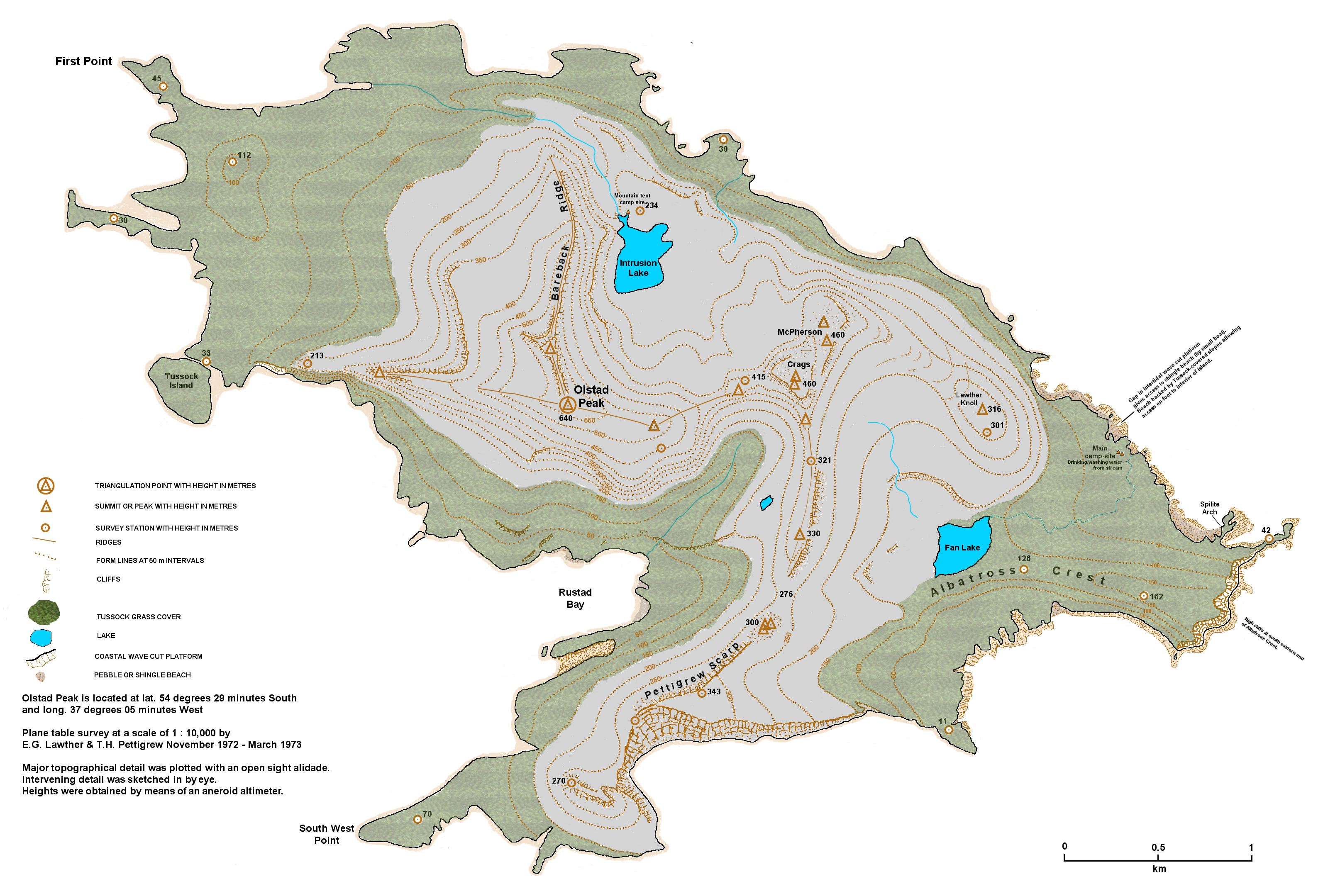
Working on Annenkov Island.

Here are some photographs which give some idea of what was involved in conducting the topographical and geological survey of the Island.

The main campsite on Annenkov Island, showing the equipment storage tent (left), and the living tent (right). December 1973. Plane table surveying on Albatross Crest (spot height 126), Annenkov Island. The metal poles with red polythene ties were used as markers for sighting between survey stations. November 1972. Eric Lawther plane table surveying on Albatross Crest (spot height 126), Annenkov Island. November 1972.
Plane table surveying at the north-eastern end of Fan Lake (at the outflow stream), Annenkov Island. December 1972. Eric Lawther ascending the ridge between Pettigrew Scarp and McPherson crags to establish a survey flag station at spot height 330 metres. Annenkov Island, December 1972. Tim Pettigrew on the beach on the north-east coast of Annenkov Island (near the landing beach), using a Jacob's Staff and Abney level to measure up a sequence of tuffs and tuffaceous mudstones exposed in the cliffs. January 1973.
Camping in the small mountain tent at the campsite located at the north-western end of Intrusion Lake. This was a useful base when surveying the north-western end of Annenkov Island. The food box at the entrance to the tent was carried across from the main camp site depot. January 1973. A Wilson's Storm Petrel in flight. Photograph taken on the south eastern slope of Lawther Knoll, Annenkov Island. The main camp site with orange tents, and the landing beach ae visible in the background. February 1973. A late evening photograph at the main camp site showing the main pyramid tent illuminated inside by the light of the Tilley lamp. Annenkov Island, December 1972.

To be Continued.


Web site first published 19th July 2017.
Last updated 22nd August 2017
© Tim Pettigrew 2017.